
Quick answer: Real-time automatic vehicle location (AVL) gives fire commanders full situational awareness by replacing radio-based status reporting with a continuously updated common operating picture (COP) that shows the live position, status, and assignment of every unit on the incident. Commanders see ground truth — who is en route, who is on scene, where each crew is operating, and how those positions relate to fire perimeter, structures, hazards, and adjacent agency resources — without having to ask. This shifts the command function from reactive information gathering to proactive resource allocation and significantly improves firefighter safety, span-of-control, and decision speed during dynamic incidents.
Fire command has always been a problem of imperfect information. The Incident Commander (IC) and the command staff make consequential decisions — where to position resources, when to retreat, what to request for mutual aid, how to protect crews from a shifting fire perimeter — using whatever picture they can assemble from radio traffic, paper maps, and the experience of the chief officers around them.
That picture has always been incomplete. Until recently, it had to be. The information was simply not available in real time. AVL changes that.
This article explains how real-time unit tracking elevates the fire commander’s situational awareness, what the gap looks like between radio-only command and a live common operating picture, and what fire agencies should look for in an AVL platform that actually delivers command-level value.
Why radio-only situational awareness falls short
For most of fire service history, the IC’s situational awareness was built from radio traffic. Units self-reported status (responding, on scene, available), positions were described verbally, and the command structure compiled that information mentally or on a paper command board. The system worked, but it depended on three fragile assumptions.
• Every unit reports accurately and promptly: In practice, status updates get delayed, missed, or batched during busy operational periods.
• The IC can hold the whole picture mentally: On small incidents, yes. On multi-alarm, multi-agency, or wildland incidents, mental tracking breaks down quickly.
• Radio traffic stays manageable: On any significant incident, the tactical channel becomes saturated, status reporting competes with tactical communication, and information gets lost.
Real-time unit tracking eliminates the dependency on those assumptions. AVL automates what used to require a radio transmission and a dispatcher’s attention, freeing the channel for command traffic and giving the IC ground truth on a live map.
What real-time unit tracking gives the fire commander
1. A live common operating picture (COP)
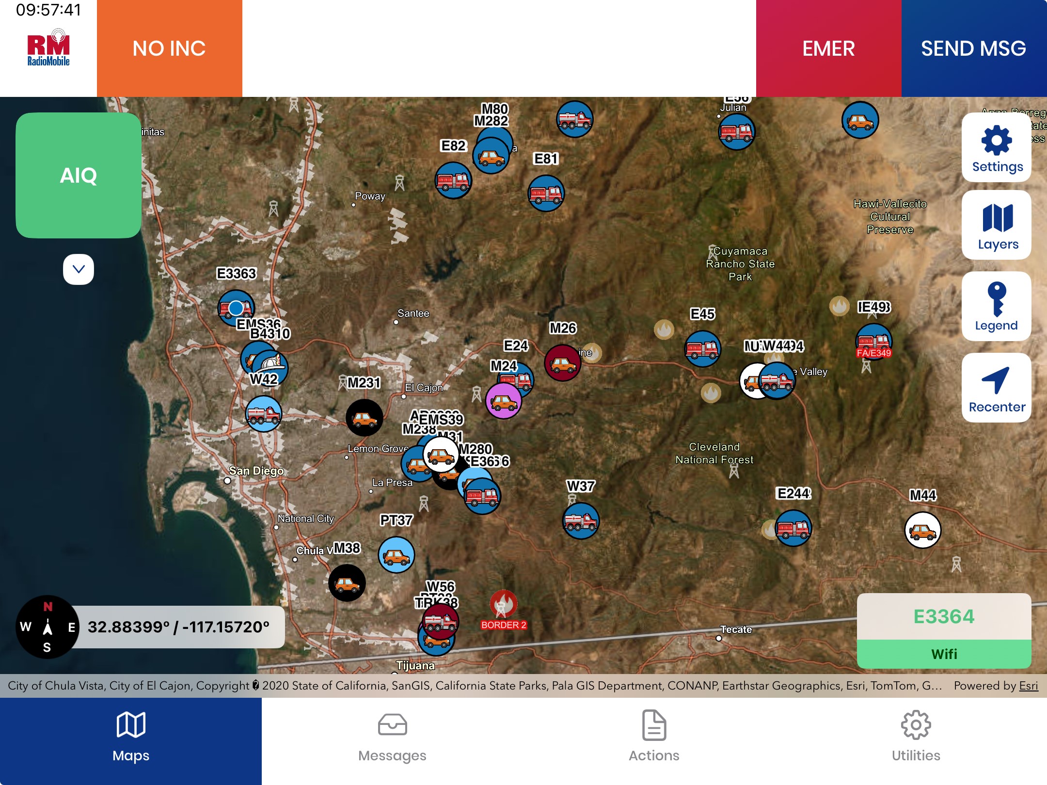
The defining benefit is a single, continuously updated map showing the live position and status of every unit on the incident. The IC sees engines, ladders, rescues, brush rigs, command vehicles, water tenders, hand crews, dozers, and aerial resources in their actual current positions. Status changes — responding, on scene, working, staged, returning, out of service — appear automatically. The command board becomes a living view of the incident, not a snapshot reconstructed from radio reports.
2. Span of control that scales with the incident
The Incident Command System (ICS) is built on span-of-control principles. A division supervisor managing five engines on a structure assignment, a branch director coordinating multiple divisions on a wildland incident, an IC running a unified command with three other agencies — all of them benefit from being able to see their assigned resources without polling each one over the radio. As the incident scales from Type 5 to Type 3 to Type 1, real-time tracking is what makes the command structure sustainable.
3. Faster, fact-based tactical decisions
Command decisions improve when they are grounded in current information. With real-time AVL, the IC can see how units are positioned relative to fire perimeter, hazards, and structure threat, then make moves with confidence:
• Reposition units: Move resources from one division to another as the incident shifts.
• Request mutual aid earlier: See gaps in coverage before they become problems.
• Stage incoming resources effectively: Direct arriving units to optimal staging areas based on actual geography, not estimated ETAs.
• Adjust the operational plan in real time: When fire behavior changes, the IC can see whether crews are positioned safely and reassign accordingly.
4. Improved firefighter safety and accountability
The most consequential benefit is safety. Real-time unit tracking lets the IC and safety officer see where every crew is operating and how those positions relate to predicted fire spread, structural collapse zones, or other hazards. In wildland operations, this is the foundation of preventing entrapment. In structural operations, it supports accountability during search, rescue, and interior attack. Combined with personnel bio-telemetry — heart rate, heat stress, location — the COP can flag responders showing signs of physiological distress before a Mayday is called.
5. Multi-agency interoperability on a single picture
Major incidents are multi-agency by default. A WUI incident might involve a municipal department, CAL FIRE, federal interagency resources, mutual aid from neighboring counties, and out-of-state strike teams arriving via EMAC. A real-time tracking platform that supports multi-agency AVL sharing — bringing all of those resources onto a common operating picture with clear agency identifiers — eliminates the coordination gaps that have historically plagued mutual-aid operations.
6. Better post-incident analysis and reporting
Every position, status change, and assignment is timestamped and logged. After the incident, the agency has a complete operational record for After Action Reviews, NFIRS reporting, ISO documentation, and continuous improvement. The same data supports operational analytics — average response times by station, coverage gaps by time of day, mutual-aid utilization patterns, and resource readiness.
What makes a real-time tracking platform actually command-grade
Not every AVL platform delivers command-level situational awareness. The platforms that do share several characteristics.
Continuous, low-latency data
Position updates should refresh every few seconds, not every few minutes. Status changes should propagate immediately. Latency between the apparatus and the COP should be measured in seconds at most, and the platform should not degrade when the network does.
Integration with incident command software
Real-time AVL data has to feed the tools the IC and command staff actually use. The strongest platforms integrate directly with incident management software like Tablet Command and RadioMobile’s IQ Mobile with the agency’s CAD platform, and with GIS layers including hydrants, pre-plans, fire perimeter, evacuation zones, road closures, and structure threat data. The COP is only useful if it is one map, not three.
Drone, sensor, and video integration
Modern situational awareness extends beyond vehicle positions. Aerial UAS feeds, ground-based cameras, weather sensors, fire-progress modeling, and personnel wearables all feed the same picture. The strongest platforms ingest these data sources — on the apparatus — and backhaul prioritized streams to the Command Center via bonded cellular and satellite paths.
Offline and degraded-network operation
Connectivity will degrade during major incidents. The COP has to keep functioning, with local data on the apparatus and the command vehicle, and resync automatically when the link returns. Platforms that go blank when connectivity drops are not command-grade.
Multi-agency AVL sharing
The platform has to support visibility of mutual-aid partner units, clearly identified by agency, without forcing every agency onto the same vendor or system.
Frequently asked questions
How fast do AVL position updates need to be for command-level situational awareness?
Update intervals of every 3 to 10 seconds are typical for command-grade platforms. Faster is better during high-tempo operations, but more frequent updates also require more bandwidth and put more load on the connectivity stack. The right interval depends on the network architecture and the agency’s operational profile.
Does real-time unit tracking replace the Incident Command System?
No. Real-time tracking is a tool that supports ICS, not a replacement for it. The command structure, the chain of command, the division and group assignments, and the operational planning process all remain intact. AVL gives the people inside ICS better information to act on.
Can multiple agencies see each other’s units on the same map?
Yes, when the platform supports multi-agency AVL sharing. Departments can elect to share vehicle locations with mutual-aid partners on compatible platforms. Resources from other agencies appear on the COP with clear agency identifiers, supporting unified command operations and crew safety on multi-agency incidents.
How does AVL improve firefighter accountability during interior operations?
AVL tracks the apparatus position, which establishes the reference point for crew accountability. Combined with personnel wearable tracking and standard accountability practices (passport systems, PAR checks, RIT operations), the AVL position anchors the team’s location to the broader operational picture. In wildland operations, vehicle-based AVL plus personnel bio-telemetry creates a more complete safety picture than either alone.
What happens to the common operating picture if the network goes down?
Strong platforms like RadioMobile’s IQ AVL cache data locally on the apparatus and the command vehicle, allowing the COP to continue functioning with the most recent data. When connectivity returns, the platform resyncs automatically. Platforms that depend on continuous cloud connectivity to function are not suitable for fireground command in environments where networks degrade.
Is real-time AVL data preserved for After Action Review?
Yes. Every position update, status change, and assignment is timestamped and logged for post-incident analysis. This supports After Action Reviews, NFIRS reporting, ISO documentation, and long-term operational analytics.
What fire agencies should evaluate when selecting a command-grade AVL platform
• Update frequency and latency: Position refresh in seconds, not minutes, with low end-to-end latency to the COP.
• Incident command integration: Native integration with Tablet Command, IQ Mobile, FireMapper, the agency’s CAD, and GIS layers.
• Multi-agency sharing: Ability to bring mutual-aid partners onto the same COP without forcing all agencies onto the same vendor.
• Offline and degraded-network resilience: Local caching, automatic resync, and graceful degradation when bandwidth drops.
• Drone, sensor, and bio-telemetry integration: A real common operating picture, not just a map with vehicles on it.
• Logging and analytics: Timestamped records of every position and status change for After Action Review, ISO documentation, and operational analytics.
• Connectivity architecture: Multi-bearer SD-WAN with cellular and satellite redundancy to keep the COP populated even when networks degrade.
The bottom line
Real-time unit tracking does not just give fire commanders a better map. It gives them a fundamentally different command capability. Decisions that used to be made on partial information are now made on ground truth. Crews that used to be tracked by polling are now tracked continuously. Multi-agency operations that used to be coordinated by phone and radio now operate on a shared picture. Span of control that used to break down on Type 1 incidents now scales with the incident.
The agencies that are setting the standard in 2026 are the ones treating real-time unit tracking as a command capability, not a back-office feature. AVL is no longer something dispatchers use to find the closest unit. It is the live operational picture the Incident Commander, division supervisors, branch directors, safety officers, and unified command all work from.
Why fire commanders choose RadioMobile
RadioMobile’s IQ AVL delivers the real-time common operating picture behind CAL FIRE and many of the largest fire agencies in California. The platform combines high-frequency AVL updates across thousands of fire apparatus with deep integration into Tablet Command, IQ Mobile, FireMapper, leading CAD platforms, and agency GIS layers. Multi-bearer SD-WAN connectivity — bonding FirstNet, Verizon, and T-Mobile cellular with Starlink and OneWeb LEO satellite — keeps the COP populated even when networks degrade. Drone and UAS feeds, personnel bio-telemetry, and fire-progress modeling all flow into the same picture. Multi-agency AVL sharing brings mutual-aid partners onto the same map with clear agency identifiers, supporting unified command operations across the most complex incidents. RadioMobile partners with agencies long after deployment to ensure command-grade performance under real fireground conditions.
Learn more or schedule a discovery call at RadioMobile.com.